Wintry weather is on the way after Storm Claudia battered parts of England and Wales and continues to pose flood risks.
Downpours which battered parts of England and Wales on Friday will be replaced with below-freezing temperatures as a yellow alert for cold weather was issued.
The UK Health Security Agency (UKHSA) issued the cold weather warning for parts of the Midlands and northern England from Monday, and the Environment Agency has warned flooding will continue throughout the weekend.
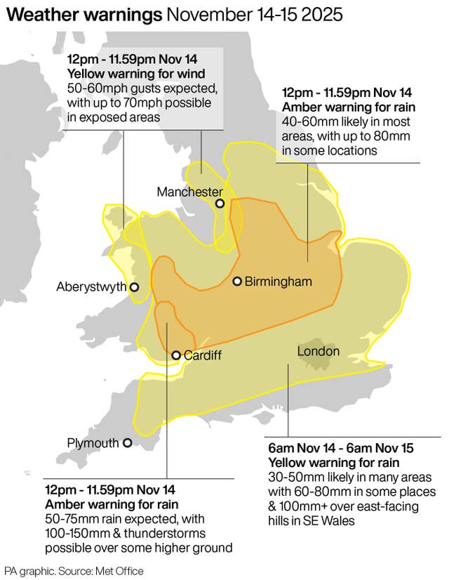
While the worst of Storm Claudia appears to be over, it is expected to bring heavy rain and strong winds through Friday evening and overnight.
Flooding is expected across larger parts of England, particularly central areas, with 156 flood alerts, meaning flooding is possible, and 33 flood warnings, meaning flooding is expected, in place.
Torrential rain is likely to continue into the weekend before colder weather sets in from Sunday, making snow and sleet possible on north-facing coasts and hills early next week, according to the Met Office.
By 4pm on Friday, the worst of the rain from Storm Claudia was in southeast Wales, with 81.8mm of rain recorded at a rain gauge at Tafalog in Gwent – already 60% of the monthly November average for the region.
Sally Davies, duty tactical manager at Natural Resources Wales (NRW) said the rain from the Spanish-named storm would be extremely heavy in parts of South East Wales and Powys on Friday.
“This could lead to severe flooding in these areas, and we want people in these areas to prepare for that possibility,” she said.

The Environment Agency said there has already been flooding in the north of England, with at least 17 properties affected.
Roadside assistance companies have reported a busy day with a high number of callouts.
Head of road safety at The AA, Tony Rich, has urged drivers in the worst-hit areas to stay off the roads until Storm Claudia has passed.
Mr Rich said: “Storm Claudia has significantly impacted operations today, with The AA experiencing an approximate 15% increase in workload because of adverse weather conditions.
“Our teams are working hard to ensure our members receive the assistance they need as quickly and safely as possible.”
Met Office meteorologist Honor Criswick said the worst of the storm appeared to be over, but warned of the cold snap setting in next week.
What comes next after Storm Claudia?
Here’s a look at the weekend forecast ⬇️ pic.twitter.com/KbG0gQLuqg
— Met Office (@metoffice) November 14, 2025
The cold weather alert is in place from 8am on Monday November 17 until 8am on Friday November 21 and covers the East Midlands, West Midlands, North East, North West and Yorkshire and The Humber.
“Overall, things are starting to ease away through the course of the night and for the beginning of the weekend in terms of the storm,” Ms Criswick said.
“Overnight (on) Saturday and throughout the course of Sunday, we will start to see winds changing to be a bit more northerly, introducing a lot of Arctic air.
“Clouds will clear throughout the course of the day so it will allow for some sunshine, but with it, it’s going to be turning much colder.
“I think people are really going to notice a chill into Sunday and feeling cold in many areas.
“Things are starting to turn less stormy, a bit brighter, but it’s going to be feeling a lot colder and, as we head into next week, we’ll see a continuation of that.”
The Met Office said colder air will bring overnight frosts for many across the UK, with lows of minus 5C possible in rural Scotland by Monday.