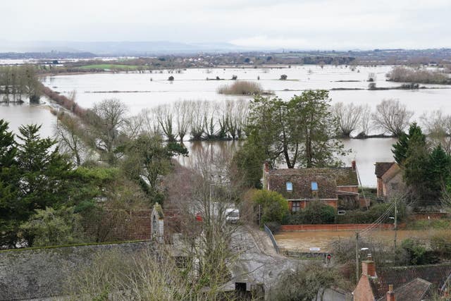
A yellow rain alert has been issued for Cornwall, Devon, Dorset and Somerset for Monday and into Tuesday, which will affect previously sodden ground.
Further rainfall could exacerbate flooding in the south-west of England in the wake of Storm Chandra, the Met Office has warned.
A yellow rain alert has been issued for Cornwall, Devon, Dorset and Somerset for Monday and into Tuesday, which will affect previously sodden ground following the recent storm.
The Met Office issued the alert from 12pm on Monday through to 9am on Tuesday, with the forecaster warning that people’s property may be at risk of flooding.
“During the Monday itself, we are gradually going to be seeing a band of rain push its way northwards from the South West,” meteorologist Jonathan Vautrey said on Sunday night.
“And so it’ll take a little bit of time, sort of pushing into the Isles of Scilly and Cornwall as we head into the start of the afternoon, and then gradually heading towards Devon, Somerset and Dorset later on in the day and into the overnight period in this area, quite widely – seeing 10 to 20 millimetres of rain.
“But locally over the hills, and particularly Dartmoor, we could see 50 to 60 millimetres of rain because this area is so saturated,” he said.
The latest warning comes after heavy rain, snow and storms throughout January.
There is heavy rain currently across parts of southern England 🌧️
This could lead to further flooding and surface water issues
Take care if you are planning to travel around here pic.twitter.com/tp9dhDtKer
— Met Office (@metoffice) February 1, 2026
“Whilst these rainfall totals aren’t going to be as high as what we’ve seen on some previous events, because it’s adding on to all the rain that we’ve had so far, it does lead to the potential of exacerbating some of the flooding impacts that are around,” Mr Vautrey said.
“I’m here at the Met Office HQ in Exeter, and I can see when I head out that fields are still waterlogged and it’s still very dampened, rivers are still running high – so that extra rainfall just brings the potential for further impacts, which is why that rain warning has been issued.
“Certainly, if your property is at the risk of flooding, then it’s worth taking notes and then taking care of that.”
Further rain on Monday could also cause difficulty on the roads and affect public transport, with fast-flowing or deep floodwater potentially causing a “danger to life” and communities becoming cut off by flooded roads.
More rain was also expected across the north-eastern areas of Scotland at the start of Monday, which would be falling as snow over the mountains, Mr Vautrey said.
A yellow ice alert has also been issued for the south-west of England, parts of Hampshire, Wales and Northern Ireland.
The Met Office has issued the alert from 10pm on Sunday through to 9am Monday, with the forecaster advising road users to beware of ice patches on untreated roads.
“We’re going to see temperatures dropping away, and certainly likely to be seeing some frost developing across Northern Ireland, as well as potentially those areas of Wales and the south-west of England,” Mr Vautrey said.
Northern Ireland could see temperatures of minus 2C to minus 4C because of the rain band that had moved across the area through Sunday, Mr Vautrey added.
“As those temperatures begin to drop overnight, that means that we have the risk of that residual water that’s around just beginning to freeze and forming those icy stretches on any surfaces that haven’t been treated,” he said.
Other regions further east could expect temperatures of around 5C in the daytime on Monday due to the cloud cover.
⚠️ Groundwater flooding in Dorset and Wiltshire
Know who to contact:🚰 Sewage issues – contact @WessexWater 📋 Groundwater flooding – contact your local council https://t.co/Cufxoh94lr orhttps://t.co/OYXkCibcX8
📝 Check flooding in your area https://t.co/5pzf457z31 pic.twitter.com/cXnevQ84MH
— Environment AgencySW (@EnvAgencySW) February 1, 2026
“Generally, we’ll be seeing temperatures ranging from around 6C to 7C in the north to 8C or 9C in the south, which is reasonably close to average for this time of the year and start of February,” Mr Vautrey said.
There were 57 flood warnings in force in England, with the majority in Somerset, Dorset and Wiltshire. There were also 119 flood alerts across the country.
Earlier this week, a major incident was declared in Somerset when about 50 properties were hit by flooding caused by Storm Chandra.
On the Somerset Levels, ultra high-volume pumps continue to be used to remove flood water, and the major incident remains in place.
Somerset Council was warning that with further rain expected there could be additional homes flooded in the Moorland, Saltmoor and Currymoor areas.
The Environment Agency said the water levels in the River Tone had stabilised and the Parrett flood relief channel had been opened to help excess water drain away.
Contingency pumps at Aller Drove and Westonzoyland had also been installed.